
Puhaina Tongariro!
E rere nei Awanui,
Ko Te Wainuinu tēnā,
Na Ruatupua i mua e
Tongariro erupts!
The great river flows,
Tis the thirst quenching waters,
Belonging to Ruatupua of ancient times
Ngāti Hāua identify predominantly in the rohe of Whanganui as an upper Whanganui River tribe but are located on borderlands between the Whanganui tribes, Ngāti Tūwharetoa, Ngāti Maru and Ngāti Maniapoto.
The Ngāti Hāua tribe is one of the tangata whenua tribes of Te Kāhui Maunga-ki-Tangaroa (the mountains to the sea), and it is through our eponymous tūpuna, Ruatupua and Paerangi from hence mana atua, mana whenua and mana tangata originates.
Synonymous with this continued occupation is the intergenerational succession of Ngāti Hāua tribal leadership initiated with Te Hoata, succeeding to Tamahina; to Tapaka; to Tūtemahurangi; to Te Pikikōtuku; to Pehi Tūroa and Tōpine Te Mamaku.
Many iwi members are descendants of Te Hoata, Tamahina and Hinengākau which is described in the expression “Te Taurawhiri a Hinengākau”- the plaited rope of Hinengākau.
Late Ngāti Hāua kaumātua Te Atawhai Sir Archie Taiaroa stated: “The taurawhiri is the binding of the whakapapa from the whanaunga iwi through Hinengākau’s descendants. This creates strength from the whakapapa alliances through Hinengākau’s marriages and other marriages. Once tied together, the people can meet any challenge.”
Rurumaiakatea
A significant pā and kāinga was established here. Rurumaiakatea was known as the place where Whanganui would congregate to face taua coming from the interior. The whānau who lived here belonged to the Ngāti Hāua hapū Hauaroa, Hinewai and Tukaiora.
Rurumaiakatea was the first pā of Ngāti Hāua to have a relationship with the Kingitanga. During the years of the colonial wars, the pā became known as a key meeting place for Waikato and upriver Whanganui. In 1876, a Crown official visiting the pā reported it as being occupied by Pai Marire. It was noted that niu poles were erected here.
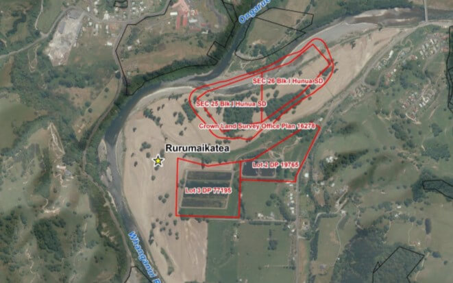
Rurumaiakatea
One of the pou associated with Rurumaiakatea was named Te Pou O Te Piki which has been identified with the King movement rather than Te Ua. The pennant flown from this pou included one bearing the image of a bow and arrow. Ngāti Hāua lost this pā as a result of being excluded from the Waimarino award. An urupā was established as part of the settlement here but it has since been built over by housing. Part of the pā is within a DOC reserve and part is used for the Hikumutu Sewerage Treatment Plant.[1]
Te Mātai
Te Mātai is a hill located between Tangarākau and Waitara. Following several hui called to settle the tribal boundaries of the Whanganui people, a meeting held at Kaipō in 1880 finally decided matters and selected several places to re-establish an ancestral boundary with Ngāti Maru and other Taranaki people. Pou were raised to mark the decisions made. At Te Mātai, the pou that was raised was named Rangitengaue. Among the party who raised this pou were Te Keepa Rangihiwinui and Kaporere Te Patuwairua[1]. Ngāti Maru did not go beyond Te Mātai, beyond that is between Ngāti Maniapoto and Ngāti Hāua.[1] Ngāti Hāua was unaware the land had been confiscated.[2]
Te Mātai
Te Mātai (meaning sentinel) pou is Rangitengaue.
Te Mātai pou is the north western boundary for Ngāti Hāua and lays near the Waiaraia block in the current Moki Conservation land. It was laid down in the time of eponymous tupuna Tamahina. Te Mātai is over the Taranaki confiscation line. Te Mātai was one of the pou spoken of in the Kōkako hui between the five major tribes when discussing the Rohe Pōtae boundary, the pou were then discussed again at the Kaipō hui and reaffirmed. This decision came about due to the land selling of the Taranaki tribes into the area of the Whanganui hapū. The carved pou Te Mātai was then given the name Rangitengaue and was erected.
Te Mātai was part of the lands that the Ngāti Hāua tūpuna Terekau (1) and Tuhaia (1) gifted to Kimihia and her sister Totoro. They were the daughters of Te Wera (Wera) who in turn was the daughter of Tamahina and Hinengākau.
Te Wera was a sister to Tapaka. Tuhaia and Terekau were the descendants of Tapaka.
It is stated that Tangarākau was given to Kimihia up to Te Mātai then to Tawhitikaupeka, a pou on the Waiaraia Block.[4] Te Mātai is located over the Taranaki confiscation line, the boundary then went up to Tawhitikaupeka. This was an old ancestral boundary and was reaffirmed at Kōkako and again at the Kaipō hui. Kimihia split off land for her sister Totoro, Tangarākau is part of the lands of Totoro.
The land over the confiscation line is what should have been part of the Maraekōwhai block. An estimation of 30,000 acres lays over the confiscation line. When questioned by the Court if the owners had applied to the compensation court it was stated, “No they could not as they, were rebels (Hauhau).”[5]
Whakapapa Island
Te Pou o Tapaka was placed on Whakapapa Island by Ngātai Te Mamaku[6]. This was done to delineate the lands of Ngāti Tūwharetoa and Ngāti Hāua after the Taupōnui a Tia boundary was put through the Native Land Court by Te Heuheu.
The boundary of Te Hoata II began at Whakapapa but was laid down long before his time. The connection to Ruataupō is Rākei, whose wife was Te Ruaroa the daughter of Te Hoata II. The son of Te Ruaroa and Rākei was Toakōhuru and his wife Hinekopa was the descendant of Tūranga i mua, the son of Turi.[7] Hinekopa was of the Ngāi Turi who lived at Whakapapa. Hakiaha stated that Ngāti Hāua, Ngāti Tamakana and Ngāi Turi lived in peace. The whare of the Ngāi Turi was Iringakawa, and Whiritoa was the pā of Te Hoata II. When Tamaio came to assist Te Hoata to fight Ngāti Hā, he and his brother Haumia went to stay with their Ngāi Turi people at Whakapapa and also at the pā, Takapuna on the Waimarino Block. This pā site is situated near the Whakapapa Road to Kākahi.
Whakapapa Island
Ngāhuinga
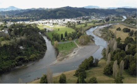
Ngāhuinga is the first rapid upriver from the confluence of the Whanganui and Ōngāruhe Rivers. Traditionally it was also a meeting place for persons who descend from the waka Tokomaru, Aotea, Tainui and Te Arawa. A kaitiaki named Titipa lives at Ngāhuinga. Titipa is known to follow or lead hīkoi on the Whanganui River. Titipa is known as an awa tupuna who protected those persons who were respectful. There are several accounts of the origin of the name Taumarunui.
Ngāhuinga
One of these accounts relates to the Hekeāwai tupuna Te Pikikōtuku I, who while on his deathbed, requested a shelter to be built to shade him from the sun. It is said that this occurred in the vicinity of Ngāhuinga at Ngāpuwaiwaha, known today as Cherry Grove Domain. A marae and papakāinga were located at Ngāpuwaiwaha until council measures brought about the removal of the community from this area. The wharepuni named Ngāpuwaiwaha was moved from the site at this time. A little to the east, Te Puru ki Tūhua was a large papakāinga on the banks of the Whanganui River. When the land here was sold, the wharepuni was dismantled and relocated.
Today the area where Te Puru ki Tūhua once stood and close by where the original Mōrero
Marae was situated is the Taumarunui Domain and Turaki Primary School. The marae was named after a taniwha who lived in a swamp that was located between what today is Hakiaha and Turaki streets. The taniwha Mōrero would make his way to the Whanganui River through a waterway that would have run around the Taumarunui Domain. The wharepuni of Mōrero Marae was named Hauaroa.
When the Crown first acquired the land, the wharepuni was moved first to Te Puru ki Tūhua. When that area was acquired the wharepuni was moved again to where Ngāpuwaiwaha Marae is now located.[8] Prior to Hikurangi and Ngāpuwaiwaha whare being built there were two other whare called Mihingutu Karaka and Huakipōuri.[9]
[1] Ngāti Hāua Iwi Trust booklet, c.2017 [p.6]; David Young, Woven by Water: Histories from the Whanganui River, Huia, Wgtn 1998, p.57: Evidence of Kevin Amohia Hikaia, 31 Oct 2008, WAI 903 #K11 Appendix, p.28
[2] Wanganui Appellate Minute Book No. 4, P,104
[3] Wanganui Appellate Minute Book No. 4.p127
[4] Otorohanga Minute Book 17, p 19
[5] Whanganui Appellate Book 4,p ?
[6] Rangitoto Tūhua No.3, Title Investigation 1897, Otorohanga Minute Book No.30, p.239: Ngāti Hāua Iwi Trust booklet, c.2017 [p.11]
[7] OMB 30, p,
[8] Ngāti Hāua Iwi Trust booklet, c.2017 [p.2]; Waitangi Tribunal, Whanganui River Report, GP Publications, Wgtn 1999 p.73: Evidence of Kevin Amohia Hikaia, 31 Oct 2008, WAI 903 #K11 Appendix, pp.27 & 29
[9] OMB 41, p 387